
Essentially, on the West End's Crab Cove section of Crown Beach, the city rezoned to residential a segment of the federal administration land that fronts the easement known as McKay Avenue, off Central Ave near Webster Ave.( See a map of the spot and more photographs and documents.)
McKay is a minimally maintained, cul-de-sac easement - not a City maintained street - and the only access point for vehicles to EBRPD's Crab Cove and the Visitor Center. This popular center caters to children and families and educates about marine and land environments and critters, the park lawn is a popular spot for kid, teen, and adult soccer enthusiasts, the BBQ areas are full in the summer, the beach is wonderful for young 'uns, and the shoreline walkways well used. All this activity means EBRPD's parking lot (about 40 to 50 slots for $$s during summer weekends, free during winter) and McKay easement itself is already full to overflowing with vehicles.
EBRPD wanted - still wants - to purchase the land to expand the park to all members of the Bay Area who hike, swim, BBQ, play, and like to hang out and relax in our public parks.
The timing of all the interlocking moments Marge describes here is unclear (city officials say one thing, EBRPD says something else, residents with differing agendas say yet something else, etc., etc.) but what is clear is that EBRPD's bid to purchase the land at public auction was, somehow, shoved aside in favor of a development company, dba Tim Lewis Communities, that proposes building residences.
The City is in favor of building residences (aka "development", "in-fill", and "complying with the Housing Element") since it allows the City to implement the state-mandated Housing Element.
Here's an excerpt from the state's website:
"State law recognizes the vital role local governments play in the supply and affordability of housing. Each governing body (City Council or Board of Supervisors) of a local government in California is required to adopt a comprehensive, long-term general plan for the physical development of the city, city and county, or county. The housing element is one of the seven mandated elements of the local general plan. Housing element law, enacted in 1969, mandates that local governments adequately plan to meet the existing and projected housing needs of all economic segments of the community." Read more ...
Now, as a side-Ramble, let Marge state that there is a faction in town who believes anything to do with the Housing Element is a ...crock.
Marge is not part of this faction.
She understands the need for something like a Housing Element in the San Francisco Bay Area; she is for affordable housing, she lives in affordable housing. And she sees the Housing Element as more than an opportunity for planners, council-people, pro-developers, etc to build housing that does not enhance our community just because cities and planners must conform to it.
In other words, Marge is not for "Housing Element über Alles."
For, Marge asks, isn't the theory in practice for urban design and planning to support communities and their residents rather than developers?
Here's Marge's hint to planners, council-people, etc: when in discussion with State officials remind them that Alameda is an island, that islands are bounded by water; islands have limited real estate; islands have limits to the traffic they can accommodate, and islands have limits to the population density they can manage.
Moreover, given the reality of sea level rise, islands will soon have even more water and even less real estate than ever; promote and elevate these realities when discussing Alameda's Housing Element!
Back to the main thread of this Ramble. The convergence of 1) pressure from the state and 2) limited time to implement the Housing Element puts Alameda in the throes of what Marge terms the "Development Thrust"...the "Develop until you Can't Develop Anymore" trend...the "Developers = Gods; Residents = Little People" mindset...the "Whaddya Mean 'Progress' Requires Some Degree of Liveability?" astonishment...the "Traffic? What traffic? Alameda doesn't have a traffic problem" denial.
Knowing this, Marge pays close attention to the development goings-on around town. (Sergei pays attention too although his efforts run to offers of support: "Keep it up, Marge. One day "they" will recognize what "development" has cost all of us.")
Goings-on around Crown Beach/Crab Cove revolve around the area that City Fathers and Mothers named, first, Neptune Pointe (yes, the "e" is supposed to be there...doesn't it add a certain je ne said quoi?) and recently renamed The Neptune Beach Project .
Based on the rezoning EBRPD sued the City claiming the procedure was out of CEQA compliance and that it requires an Environmental Impact Report.
Recently, the Planning Board held a special meeting to hear public comments about the Project before generating an EIR (to be paid for by the developer).
Facts shared with the public are in short supply although there is a continuously evolving body of unpublicized legal and development facts ...along with oodles of fiction, fantasy, and wishful thinking.
Since pictures are said to be worth a thousand words, Marge shares here facts in pictures...plus her grassroots knowledge based on many Rambles in the disputed area as well as her attendance at Planning Board meetings.
A bit of history... from Wikipedia:
"Between 1917 and the start of World War II, the area around the [Crab Cove] visitor center was part of Neptune Beach, an amusement park and resort community that featured bathing spas and waterfront houses.
During World War II, the site was used as a training base for Merchant Marine commanders. The park was subsequently known as "Alameda Memorial Beach" until it was renamed for a local politician [Robert Crown] who was struck and killed by a vehicle while running (jaywalking). The current visitor center building was used as the base infirmary." (Read more.)
Aerial and schematic views

This aerial view - presented in a City Planning doc - shows the layout of the currently disputed 3.89 acres.
The "U" shaped residence on the left is Crown Harbor. McKay easement runs to the right of the red line on the right. (EBRPD Visitor Center roof quite visible with Crab Cove to the right of that.)
The waters of Crab Cove Marine Preserve are right foreground.
Also compliments of City Planning, below, the schematic of the proposed complex... Marge added the red boundaries for clarity....

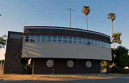
The schematic shows the extent of the proposed development adjacent to the "Gate", the area where EBPRD stores its equipment and uses a fabulous historical ship-shape building, and McKay Ave. Marge will share more about this historical building in a future post. For now, though, this building, while high, is singular and, rather than loom over a human being, it intrigues.
See below for a drawing of the homes proposed. Too bad the architects didn't take a lesson from whomever designed this historical building....
As another aside, at the recent special Planning Board meeting, President David Burton addressed population density for the proposed community (what Marge describes as "stuffed with residents": “This plan seems like we’re just warehousing people. It doesn’t address the proximity to the park. We’re just packing them in here, in a three to four bedroom house, with almost zero outdoor space for these folks. I would like to see something more gracious.”
Bravo, Burton!
McKay Ave, being an easement, is the fly in the developer ointment.
EBRPD has refused Lewis Communities access via McKay. If access has any chance of being granted lots more City diplomacy will be required. Based on recriminations observed in the current and past law suits between the city and EBRPD, diplomacy is in short supply.
"Gate"
Marge circles "Gate" on this schematic to express her anxiety about a walkway that, during daylight hours, allows public access through the Crown Harbor complex. The walkway winds along Sunny Cove and exits on Central Ave. (See Rambles 27and 23 and 13 and 12 to see how lovely is the area around which this walkway wends.)
Look again at the schematic...then look at the pix below.
Doesn't it look as if the proposed buildings will come right into the park and impede access to this gate?
Devil in the details:

View looking towards what would be the front of the proposed site with public access gate barely visible behind the fence to the left.
Imagine standing where Sergei was standing when he shot this pic...
...then imagine turning around...
...this is what you'll see


Here's a wider angled view of the Gate to/from the Crown Harbor path through the gate heading towards Crab Cove.
That's EBRPD "ship" building's roof just visible in the mid-left background.
The schematic implies that the proposed buildings will extend beyond the area now occupied by that lovely tree and alongside the wooden fence shown in the mid-ground...where you see the walkway angle to the right.
(Below) Here's a view of the sort of housing planned. Yes, three storeys high (one assumes these adhere to West End building height limits), 2-car garages under the 3 bedroom places. (Thanks to Planning Board doc for this drawing. See more such docs.)
Don't know about you but, looking at the density proposed in the above schematic and then at these homes - Marge is suspicious that the two illustrations don't really match up - she already feels that sense of foreboding as buildings this high loom over the area and detract from the sense of openness that makes the public walkway and this park such a pleasure.
Is there space here for human beings to stretch their arms without touching a neighbor? What about space to swing a cat?


Tim Lewis Communities had hoped Crown Harbor community would allow Lewis Communities residents access via this road.
That hope seems to have come to naught so...back to the drawing board.
The avenue of trees (Alameda in Spanish means avenue of trees) is home to many families of birds. Marge discovered this very early one spring/summer morning when she walked this area and was entranced by bird song.Very sad to know that this lively bird community will be disrupted, likely forever, by construction, etc.
By the way, Crown Harbor homes are two storey duplex-style, lots of lawn and space for human beings to at least stretch their arms and swing the occasional cat.

The public access walkway heading toward the gate. Kings Road amid the trees to the left. Crab Cove just beyond the spit; the row of buildings on very distant horizon is Harbor Bay.
Sigh.
Marge wonders, where is Neptune, the god of fresh and sea water, when needed? Would that he'd rise from his watery realm and have a heart-to-heart chat with our City Fathers and Mothers about the necessity of protecting the dwindling natural world. (Neptune, in case you're wondering, is a Roman god; the Greeks version is Poseidon - read more about this.)
In another decade natural environments in Alameda and the Bay Area will be worth far more than City Fathers and Mothers can imagine right now. Moreover, they (City Dads & Moms) would be recognized as urban visionaries, saviors of precious "vistas", superior beings who saw fit to preserve what ought to be preserved, along the lines of David Brower, John Muir...and beloved of Neptune and The People.
Learn more about Neptune Beach Project see this map of the spot and more photographs and documents pertaining to it..
Great article/rambling! Please c/o friendsofcrownbeach.com and Like us on our Facebook page too. I've added a link to this article and to all the documents/maps/pix you've compiled to our Facebook page.
ReplyDelete